Tellurion: a small deployment with explicit capabilities
Independent creator and owner
Tellurion is my independent Rust geospatial serving engine. It combines a small self-hosted deployment with capability-aware geospatial interfaces and public evidence that readers can inspect.
Problem: evaluate geospatial serving without a large platform
A geospatial server should be useful before an evaluator commits to a fleet of services. At the same time, a small default deployment should not hide the limitations of its storage and protocol implementations.
Tellurion starts from a native serving engine and an embedded GeoPackage path. The architectural challenge is preserving that accessible entry point while supporting other storage capabilities and inspectable data journeys.
Architecture: native serving, routed storage
The repository describes a Rust engine with OGC API and STAC surfaces, routed storage drivers and an embedded GeoPackage default. PostGIS is an optional storage choice for deployments needing its capabilities.
The public gallery preserves separate vector, raster and other demonstration journeys. A STAC discovery case connects a bounded WorldCover Item to GeoPackage and COG serving lanes, with provenance and live resources for inspection.
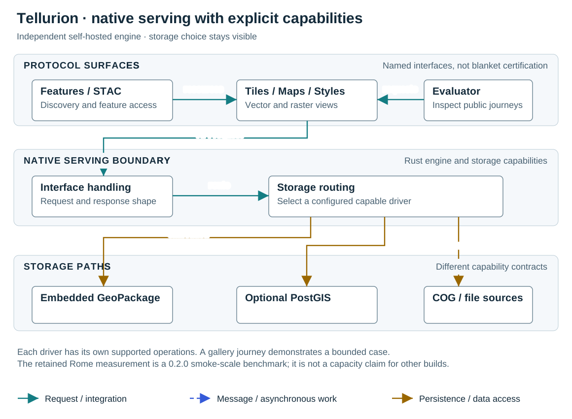
The architecture diagram deliberately separates protocol surfaces from storage capabilities. It does not imply every driver implements every query or format.
A native engine with distinct storage capabilities
Clients use geospatial interfaces through one native engine. GeoPackage provides an embedded path; PostGIS provides a separate database path; COG and other supported sources use capability-specific serving. Public demos illustrate bounded journeys rather than a uniform backend contract.
Decisions: make evaluation boundaries visible
The embedded default reduces infrastructure requirements for evaluation. A database service remains a choice rather than a prerequisite for every run. Driver capability limits must be explained alongside the API surface.
The gallery includes source and evidence, retained version entry points and dated artifacts. A public walkthrough demonstrates an edited journey; it is not a throughput benchmark. Likewise, hosted response timings are affected by the demonstration environment.
For a retrospective architectural comparison, I would consider a deployment that always requires a database. It could simplify uniform server-side spatial behavior but increases the minimum setup. Tellurion’s embedded path makes that tradeoff visible to an evaluator.
Outcomes: self-hosted software and public journeys
Tellurion’s public source and demonstration gallery let readers inspect its serving approach. The independent project is distinct from FAO institutional work. Community source is offered under AGPL-3.0-only; the repository and release documentation define applicable terms.
The retained Rome result is a Tellurion 0.2.0 smoke-scale benchmark with its own method and caveats. It is not generalized to later releases or other datasets. Demonstrated standards behavior is not presented as certification or blanket conformance.
The project offers self-hosted software; it does not offer a Tellurion Cloud service or a service-level agreement.
Learning: a demo is stronger when its claim is bounded
A credible evaluator journey should identify the build, data source, interface and limitation. A short map preview can be valuable evidence of that journey while remaining insufficient evidence for general capacity or availability.
For a deployment decision I would measure the intended dataset, query mix and chosen driver directly, and verify unsupported capabilities explicitly rather than treating a successful gallery example as a universal guarantee.
Questions & discussion
Why use GeoPackage as the default?
It supports a self-contained entry point without a required database service. PostGIS remains a separate capability choice for more demanding workloads.
Read the relevant sectionDo the demos prove full OGC conformance?
No. They evidence named behaviors and bounded journeys. Certification or general conformance requires a separately scoped assessment.
Read the relevant sectionCan the Rome benchmark predict another deployment?
It is a retained 0.2.0 smoke-scale result. Its dataset, build, method and caveats apply to that measurement; another deployment needs its own benchmark.
Read the relevant sectionSources & scope
- Tellurion Community source
Public repository and local source documentation inspected October 2026; release evidence is version-specific; Independent project by Carlo Cancellieri
- Tellurion public demonstration gallery
Versioned demonstrations and proof links retained on portfolio; Author’s public demonstrations
- Tellurion proof brief
Bounded public evaluation evidence; Author’s evidence collection